🏗️ Breaking Ground on 17th Street: Your Guide to the ViBe Corridor Transformation
“A safer, smarter Virginia Beach Boulevard is on the way.”
— City of Virginia Beach press release
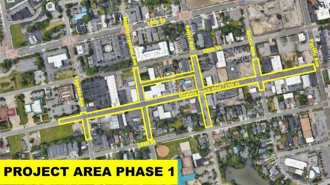
⇨ A rendering / schematic of the Phase 1 project area along 17th Street / Virginia Beach Blvd.
⇨ Phase 1 spans from Pacific Avenue west to Cypress Avenue, and includes adjacent cross-streets (Cypress, Mediterranean, Baltic, Arctic) between 16th and 18th streets.
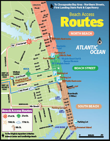
⇨ A beach access / routing map around the resort & boardwalk area.
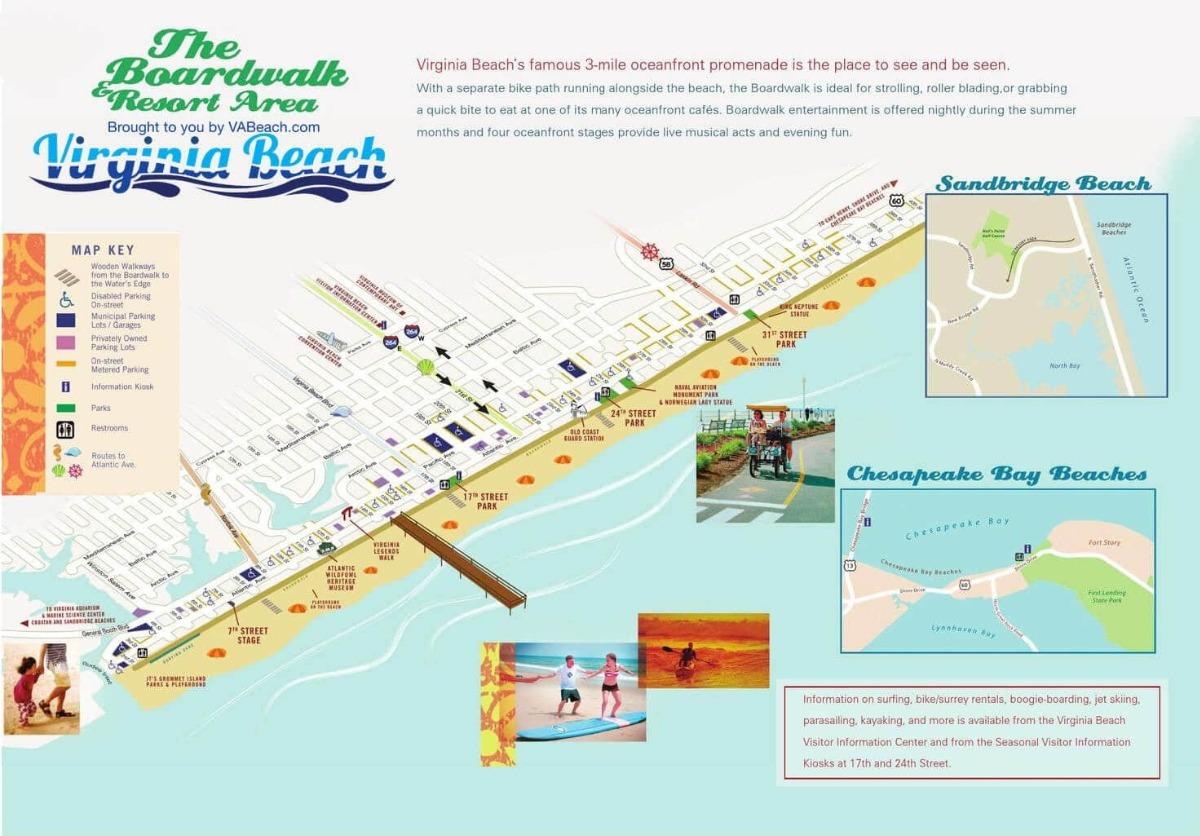
⇨ The general resort / oceanfront area layout.
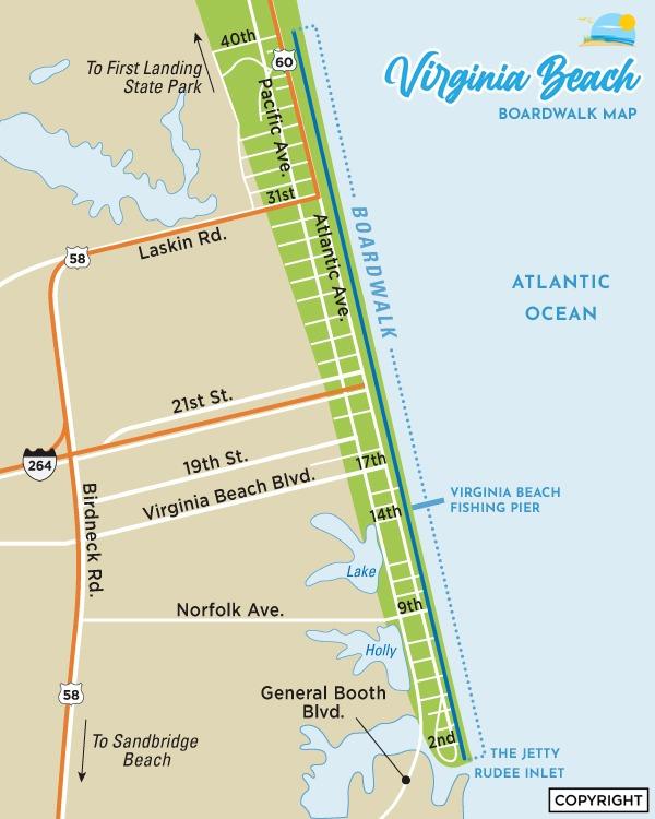
⇨ A boardwalk / street-grid map showing 17th Street’s relation to Atlantic / Pacific / 19th Street.
Once fully implemented, the new corridor will feature:
| Improvement | Benefit / Purpose |
|---|---|
| New water, sewer, and stormwater systems | Reduce flooding, upgrade aging infrastructure. |
| Wider sidewalks & travel lanes | More comfortable pedestrian space and safer vehicular flow. |
| Dedicated bike lanes | Encourage cycling and safer multimodal connectivity. |
| Modern lighting, crosswalks, and signal upgrades | Better visibility, safer crossings, more efficient traffic control. |
| Streetscape, landscaping & ViBe signage | Offer visual identity, green buffers, and sense of place. |
| Undergrounding power & utilities | Remove overhead clutter and strengthen infrastructure resilience. |
This isn’t just a surface refresh — it's a full corridor reinvestment to modernize, beautify, and better connect parts of the resort, ViBe district, and commercial corridors.
Work is expected to take about 3½ years (~October 2025 to March 2029)
Here’s a detailed breakdown:
| Phase | Focus / Scope | Timeline Estimate | Closure / Traffic Impact | Notes |
|---|---|---|---|---|
| Phase 1 – Underground utilities | Water/sewer line replacement; initial streetscape prep | Oct. 2025 → ~May 2026 | One block + one intersection at a time. | Oct 6–9: Arctic Ave / 17th St intersection closure for sampling & mobilization. Oct 10–24: Full block closure from Pacific → Arctic for exploratory work. Oct 27 – Dec 23: Utilities installation, closures at both block & intersection. |
| Phase 2 – Electrical, comms, widening, stormwater & streetscape | June 2026 → Dec 2027 | 2 lanes open / 2 lanes closed | Ongoing work along those elements. | |
| Phase 3 – Northside widening, drainage, streetscape | Jan 2028 → Dec 2028 | 2 lanes open / 2 lanes closed | Continues corridor enhancements. | |
| Phase 4 – Lighting, landscaping, signage | Jan 2029 → Mar 2029 | 3 lanes open / 1 lane closed | Final touches, aesthetic elements. |
⇨ Closures will be phased and localized—the contractor is required to maintain business access and coordinate closely with property owners.
⇨ Expected detour routes include 21st and 22nd Streets during full-block shut-downs.
⚠️ What Locals & Guests Should Know
Tips for Navigating During Construction
-
Allow extra travel time — shifting lanes and congestion are likely.
-
Follow signage & flaggers — they’ll direct traffic flow safely through work zones.
-
Use alternate routes during full-block closures (e.g. via 21st / 22nd).
-
Pedestrians / cyclists may find non-vehicular paths more reliable in some phases.
-
Businesses stay open! — Don’t be deterred; local shops and restaurants intend to remain accessible throughout.
One business owner said: “It’s one of those things that’s been way overdue… I think it will open the street and provide a safe way for people to get back and forth from the Oceanfront."
🌟 Why This Matters for the Future
This project isn’t just a refresh — it’s an investment in:
-
Safety & accessibility for all users: pedestrians, cyclists, drivers
-
Infrastructure resilience (better drainage, underground utilities)
-
Connectivity between ViBe, Resort Area, and commercial corridors
-
Economic vitality & tourism appeal — beautified corridors, updated infrastructure
-
Long-term reinvestment: Phase 1 is funded via the City’s Tourism Investment Program, redirecting tourism revenues back into local infrastructure.
💌 Stay In Touch & Learn More
-
Subscribe to project email updates via the City’s website or the QR code in the project flyer.
-
Visit the official project pages: “17th Street / Virginia Beach Boulevard Improvements”
-
Questions or suggestions? Email [email protected]